
Maps
Use the Maps app to route your trip, explore an area for landmarks and shops, and check traffic flow. Maps can show you the route to your destination if you are driving, walking, cycling, or taking public transit.
Maps has indoor maps for some major buildings, airports, and malls—even some casinos in Las Vegas—with many more to come. If you see a pin on a map with “Look Inside” just beneath the pin, tap it to view the 3D map!
Navigating Maps
Use gestures to move around on the Maps screen.
- Drag to move the map in any direction.
- Use two fingers to pinch in or out to zoom in or out.
- Tap on icons and locations to select them.
- Place two fingers on the screen and rotate them to rotate the map view.
- Double-tap with one finger to zoom in.
- Double-tap with two fingers to zoom out.
Turn on Precise Location
The Maps ![]() app uses GPS and local signals, like Wi-Fi and cellular towers, to pinpoint your current location. You must be connected to the internet and enable Precise Location for Maps to work its best.
app uses GPS and local signals, like Wi-Fi and cellular towers, to pinpoint your current location. You must be connected to the internet and enable Precise Location for Maps to work its best.
- If Maps is displaying a message that Location Services or Precise Location is off, tap the message and turn the features on in Settings.
- To turn Location Services or Precise Location on go to Settings > Privacy & Security > Location Services.
Maps shows your current location
You can always find or return to your current location by tapping ![]() at the upper-right corner. By default, the top of your screen is north. You can tap
at the upper-right corner. By default, the top of your screen is north. You can tap ![]() again to change Maps to show your heading at the top of the map. Tap
again to change Maps to show your heading at the top of the map. Tap ![]() or
or ![]() to change back to showing north at the top of your screen.
to change back to showing north at the top of your screen.
Real-time traffic information
Maps use crowd-sourced data from cars traveling streets and highways to calculate traffic flow. This real-time traffic flow information helps you avoid traffic jams, accidents, and other delays. You can plan a trip with multiple stops and choose between the alternative routes Maps offers.

Exploring Maps
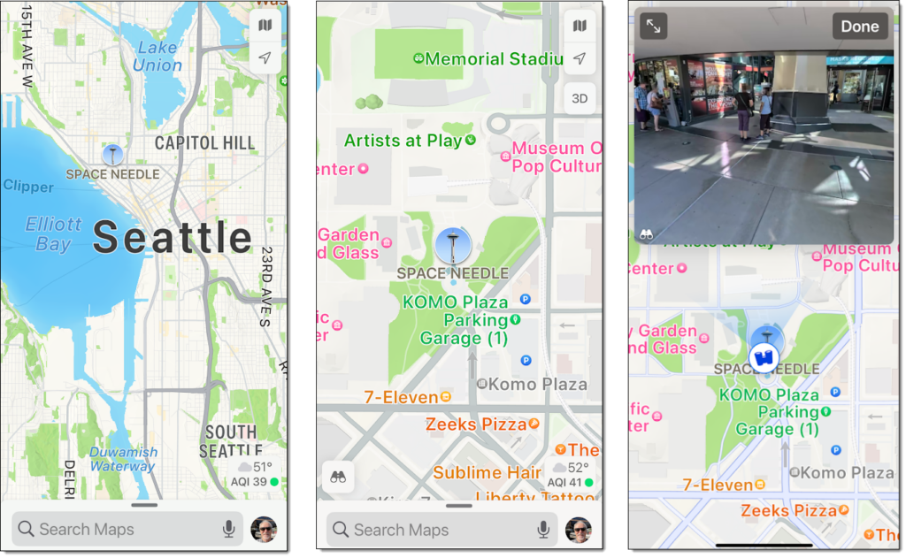
The detail you see on Maps depends on your zoom level. If you are zoomed way out you’ll see states, cities, and major landmarks. More detailed information is displayed as you zoom in. When you have zoomed in closely enough you’ll see street and business names as well as parks, museums, and other locations with general interest value. In the image below I’ve zoomed from a far-off view of Seattle down to viewing a gallery photo of the entrance to the Space Needle. Tap ![]() to view images and details of an area or location.
to view images and details of an area or location.
Searching Maps
Maps will suggest locations based on your searches for business names, e.g., “Hilton,” or business types, e.g., “hotels.” Tap the search box, and Maps will suggest popular searches, e.g., restaurants and gas stations nearby.
Maps can display satellite pictures, show real-time traffic conditions, give you turn-by-turn voice directions, and even display customer ratings for restaurants, hotels, and other businesses. You can also grab a ride from Lyft or Uber or book a reservation from Open Table—right from within the Maps app.
Choose the right map
You can choose between views by tapping the icons shown below. You’ll find them at the upper right.
- Exploring
 . Hides traffic and transit data so that more area information (landmarks, business names, etc.) can be shown.
 - Driving
 . Displays traffic data.
 - Transit
 . Displays public transit data.
- Satellite
 . Replaces the drawn map with a satellite image.
- Satellite
Find Nearby
For quick access to popular searches nearby, including food, drinks, and shopping, tap the search field, then choose from the Find Nearby categories.
Explore new places with Guides
Guides are curated by brands and partners for Maps. They can help you find great places to eat, shop, and explore. Preselected Guides are just below Find Nearby, or tap Explore Guides to narrow by place or publisher.

Searching for a location by name
Open Maps and use the search field to type in searches by business name, city, or landmark. You can also summon Siri and ask or tap
![]() and speak your search terms (must be connected to the Internet). Besides actual street addresses, you can use search terms such as:
and speak your search terms (must be connected to the Internet). Besides actual street addresses, you can use search terms such as:
- An area like “soho new york” (notice that capitalizations aren’t important if typing).
- An intersection like “broadway and 5th.”
- A landmark like “statue of liberty.”
- A city name like “st louis” (add a state if there are multiple cities with the same name).
- Zip code.
- Type of business like “dry cleaners” or “restaurants.”
- Type of food like “mexican food” or “deli.”
The search result is displayed in a search card. Depending on the location, you’ll find contact information, customer ratings, pictures, what Guides, if any, the location is featured in, and much more.
Zoom in for area detail and Look Around
The closer you zoom into a map, the more detail Maps will show.
- Zoom in on an intersection or shopping mall. Business names appear as pins with icons denoting the type of business when you are zoomed in far enough.
- Tap the location pin, then swipe up to view more information.
- Some locations may include 360-degree photos. Tap
 to open the photo. You can then drag the picture to look around the entire area.
 - Some locations have interactive features like Flyover. On a place card, tap Flyover to view a location from above. Flyover might be hidden in the More
 menu.
menu.
Maps may include phone numbers, business hours, website URL, and more.
Sharing a location
You can quickly share your current location or any map location using a text message, email, AirDrop, or social media.
- To share your current location, tap the blue dot that denotes your location, tap
 , then choose a contact or a delivery option such as Mail or AirDrop.
 - To share a business or other location, open the location card in Maps, then tap Share and choose a contact or delivery option such as Mail or AirDrop.
Traffic conditions
Maps on iPhone can show you current traffic conditions that could affect your drive. Maps will use traffic delays, known crashes, and road closures when calculating your route.
- Tap
 and turn on Driving.
 - Slow traffic is shown as a red line.
- Maps indicates other road conditions like:
- Crashes
 .
. - Road closures
 .
. - Road construction
 .
. - Other alerts
 .
.
- Crashes
Turn-by-turn directions
Maps can give you turn-by-turn directions to your destination. Maps will adjust your route based on real-time traffic and road conditions and even recalculate your route if you miss a turn.
- Open your destination in Maps (use the search function or tap the screen to designate a location).
- Tap Directions.
- If necessary, choose between alternate routes.
- Make sure the correct transportation type (drive, walk, bike, etc.) is selected.
- Tap
 to start audible turn-by-turn navigation.
 - View the map for lane guidance, ETA, speed limit, and more.

Maps can help you with the weather
Current and forecast weather conditions are built into Maps.
- Center over the area of interest.
- Zoom in until the weather icon, which shows current conditions for that area, appears in the lower-right corner.
- Long press the Weather icon to see the hourly forecast.

Save a location from Maps
While viewing info about a location, scroll to the bottom of the location card. Tap Add to Favorites to find the location easily in the future.
A quick and easy way to mark your current location so you can find your way back later: touch and hold the Maps ![]() button on the Home Screen, then choose Mark My Location from the Quick Actions menu.
button on the Home Screen, then choose Mark My Location from the Quick Actions menu.
Maps isn’t perfect—and it requires a data connection
Many features of Maps and other location-based services depend on the data services available when using the app—cellular, Wi-Fi, and GPS. These services may not always be available, and the apps may not function as needed. Also, you will sometimes find errors in any mapping app or GPS tool.
If you need a map available offline, take a screenshot. You can then view your route in Photos.
Using other apps connected to Maps
You can use other apps, like Lyft, Uber, and Open Table, from within Maps on your iPhone if you:
- Have the app installed on your device.
- Have the app enabled in Settings
 > Maps (Ride Booking Extensions and/or Table Booking Extensions).
For ride extensions to show up, find your location and tap Directions, then look for the Ride Share button in the transportation type dropdown menu.
